Advanced Water Observatory and Decision Support System

What We Do

The Advanced Water Observatory and Decision Support System (AWODSS) harnesses the power of data and visualizations from observational platforms and modeling systems to inform short-term water decisions and plan for alternative water futures. AWODSS is leading to the creation of new technologies, fostering entrepreneurship and job creation through startup companies and helping train personnel at partner organizations in the water and environmental sectors, including the Central Arizona Project, Arizona Department of Water Resources, Salt River Project, Arizona Department of Environmental Quality and private sector firms.

Decisions related to water supply, ranging from construction permits to agricultural allocations, depend on the availability and quality of water monitoring data and forecasting tools. At present, water supply decisions are known to suffer from long delays, high costs and a limited capacity to adapt to future change. Nothing short of a transformational approach is needed to modernize how water is monitored, analyzed and predicted.

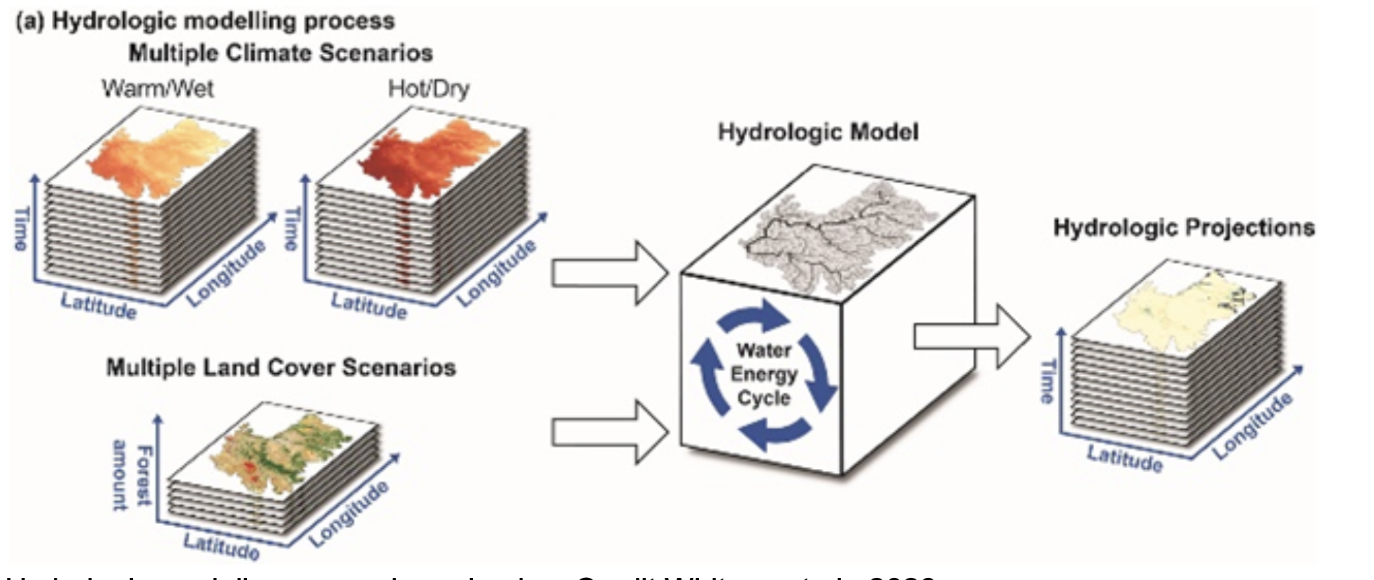
The AWODSS approach to this needed change is to provide decision support infrastructure based on Earth observing systems, numerical prediction systems and big data analytics, visualizations and artificial intelligence. Real-time data and analysis products on Arizona’s surface and groundwater are being shown to a wide range of audiences, including decision makers and elected officials. These hydrologic analyses serve as a backbone for integrated assessments that cut across several other spaces including agriculture and power generation.

Innovation and Impact

AWODSS is revolutionizing water measurement, modeling and prediction and providing data necessary to identify critical risks, vulnerabilities and capabilities in hydrologic systems. The observatory is deploying state-of-the-art technology to fully map, monitor and model all of Arizona’s water supplies.

Leading-edge technologies are helping overcome long delays and the large cost of water resources decision-making, thus allowing for better adaptive management strategies. This investment is enabling ASU to partner with federal and state agencies, local water management agencies, research institutions and the private sector to enhance water security and reduce risks of future water shortages.


Leadership

Featured projects


A Dove satellite from the aerospace company Planet. Credit: Planet

Streamflow Presence and Flood Hazards 

Dr. Vivoni and Dr. Wang developed a new approach to using Earth-observing satellites to detect the presence of flowing water in arid and semiarid rivers in California and Arizona. This project uses small commercial satellites called CubeSat, typically the size of a shoebox, that can orbit the Earth and even travel in deep space. In contrast with traditional methods based on labor and time intensive ground-based field surveys, this approach is allowing the team to assess streamflow regimes of rivers across large arid and semiarid regions at very high spatial and temporal resolution. Learn more.

Hydrologic modeling across large basins. Credit Whitney et al., 2023
Hydrologic modeling across large basins. Credit:Whitney et al 2023    Image description

Climate Change and Water Supply

In collaboration with the Central Arizona Project and 14 other water management agencies, ASU’s team of researchers developed the Colorado River Basin-Scenario-Explorer. The Scenario Explorer is an online visualization tool with the ability to simulate scenarios like droughts and forest disturbances, enabling users to explore and understand the impact of climate change in the Colorado River Basin. Future improvements to the project include updating the water visualization tool so that it auto-populates with real-time data and modeling information from NASA and other agencies. The use of satellite observations and hydrologic modeling will greatly improve water resource decisions and management. Learn more.


C.C. Cragin Reservoir in northern Arizona. Credit to https://blog.srpnet.com/
C.C. Cragin Reservoir in northern Arizona. Credit to  https://blog.srpnet.com/

Forest Health and Water Resilience

ASU and Salt River Project are working together to understand the effects of forest thinning on the hydrologic cycle. The Triangulated Irregular Network-based Real-time Integrated Basin Simulator was used to provide insight into the effects of forest cover reduction on the hydrologic response of watersheds in the Salt-Verde River system. Strategic forest thinning efforts help reduce the threat of catastrophic wildfire and could be a possible solution to protecting our water supplies. Learn more.